A classic ski mountain, Mt Sibbald has 1800m vertical from the base to summit. Situated up the Macauley River it takes just under 3 hours of 4wd action to get there from Tekapo. The initial section of road to Lilybank station is straight forward, but from Lilybank to Macauley Hut it is 4wd country. The 4wd section starts with a marked crossing of the Macauley river which is pretty straight forward, but if there has been any rain or moderate snow-melt it can be tricky. In dry conditions the water will be at teh bottom of the doors, in wet conditions it can be over the bonnet or deeper!. In spring this river is also popular with jet-boaters, to give you an indication of possible flow. If in doubt have a look at the website for Environment Canterbury – http://ecan.govt.nz/services/online-services/monitoring/river-flows/Pages/River-flows-south.aspx Check out the Ahuriri river which is monitored. If the flow is around 30 cumecs or below in the Ahuriri, then the Macauley should be ok.
After the crossing the route is rutted for the initial section, then improves vastly until the last half hour which is riverbed travel, incipient tracks, lots of bumping around and river crossings. You will need a low range gearbox and some clearance (read: Landcruiser not RAV 4). Try to remember your route in, just in case you are driving out in the dark after skiing
Macaulay hut is possibly the nicest hut in the NZ back country. There is electricity, running water, gas stoves, kitchen utensils, double beds even!. Pure luxury.
No 4wd access is permitted past the hut so it is skis on the back and walking. There is a reasonably good track leading out from the hut to the upper Tindill Stream which is quite expedient. The valley doesn’t catch a lot of sun so you can expect to be skinning within an hour from the hut. The initial section of the Upper Tindill Stream goes very quickly with straight forward valley travel and eventually skinning, with some very interesting terrain with giant medial moraines, and even a wee frozen lake at 1650m. Tend towards the true right on the way up to avoid going up and down the moraine walls.
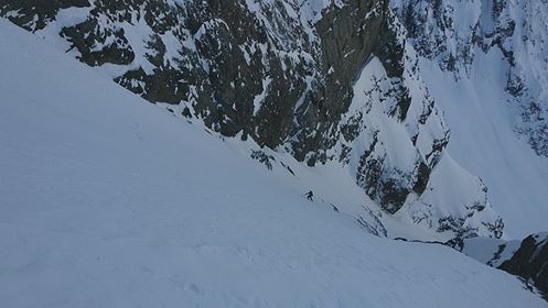
The section from the wee tarn to the col is a massive 650 m skin. It doesn’t look like it from the bottom but it is. The gradient is such that it is possible to skin right up to a bottleneck at about 2200m where the valley and glacier narrow. Here it might be necessary to crampon through. The slope is about 40 degrees with a few small bergschrunds. Crampons, axe and a length of rope are advisable. This area would load heavily with wind-loading, and the whole valley is threatened from many aspects should the avo hazard be anything other than relatively low. Use judgement. Once on the ridge the angle and effort ease way back, and the views are excellent of DÁrchiac and the terminal lake of the Classen.
There is a further steep pitch at about 2600m which has about 50-100m vertical at close to 45 degrees at its max. Then push for the summit, and if you don’t feel knackered by then you are a true machine!
Ski back down the route or down the East Glacier face. We took 6 hours up; 20 minutes ski descent. An excellent ski tour. Get into it!


You must be logged in to post a comment.